It may be that no modern nation-state has been called “artificial” more times than Iraq. While most scholars are quick to admit that all nation-states are artificial, in the sense that they are created by humans, Iraq, it would seem, is more artificial than most. The story invariably begins with the post-World War I peace settlements, during which the borders of Iraq, along with those of the other Arab Mashriq states, were purportedly created, more or less out of thin air, by Europeans. As David Fromkin writes, in his widely read A Peace to End All Peace:
It was an era in which Middle Eastern countries and frontiers were fabricated in Europe. Iraq and what we now call Jordan, for example, were British inventions, lines drawn on an empty map by British politicians after the First World War, while the boundaries of Saudi Arabia, Kuwait, and Iraq were established by a British civil servant in 1922.[1]
It is a narrative we are all familiar with, since it has been repeated by scholars, journalists, and political commentators of all stripes for close to a century now. I have repeated it myself on a number of occasions.
The “artificial state” narrative was also invoked by the Islamic State (IS)—formerly known as ISIS—when the group released a video called “The End of Sykes-Picot” in the summer of 2014. It proclaimed that the dissolution of the Syria-Iraq border spelled the end of the nation-state system imposed on the region by the colonial powers after World War I, and promised that “This is not the first border we will break.” Speaking from a mosque in Mosul in July, the group’s leader Abu Bakr al-Baghdadi explained: “This blessed advance will not stop until we hit the last nail in the coffin of the Sykes-Picot conspiracy.”
A flurry of media commentary ensued, and Sykes-Picot maps popped up across the Internet as supporting evidence, or at least supporting decoration, for a range of opinions on the IS pronouncement. The dominant response, even among staunch opponents of IS, seemed to be that the group was indeed undoing the infamous 1916 Sykes-Picot Agreement between Britain and France divvying up the Arab lands of the Ottoman Empire, and that this was the logical demise of artificial borders created by the colonial powers a hundred years ago. A Reuters article, entitled “Sykes-Picot Drew Lines in the Middle East’s Sand that Blood is Washing Away,” explained that the agreement had been “an inherently imperial project, which paid scant regard to geography, terrain or ethnicity.” Public intellectuals from the far right to the far left agreed; even before the IS advance, Noam Chomsky was quoted as saying that “the Sykes-Picot agreement is falling apart, which is an interesting phenomenon . . . But, the Sykes-Picot agreement was just an imperial imposition that has no legitimacy; there is no reason for any of these borders—except the interests of the imperial powers.” There were a few dissenting opinions, most of which questioned whether the Iraq-Syria border was really dissolving. For example, Steven Simon wrote in the August issue of Foreign Affairs: “Thus far, the parade of horrors emanating from Syria has not included the demise of the Sykes-Picot borders . . . In short, despite the regional pandemonium, Sykes-Picot seems to be alive and well.”
Rarer were critiques of the Sykes-Picot narrative itself or the broader artificial state narrative of which it is one strand. There were some notable exceptions, including a brilliant piece by Daniel Neep arguing that the fascination of pundits everywhere with how a better map of the region might be created is “no more than a fantasy concocted from a phantasm, an illusion distilled from the fragments of a half-remembered dream.”[2] But for the most part, the fragments of the half-remembered dream held sway. Indeed, few even bothered questioning the claim that the border IS was challenging had in fact been created by the 1916 Sykes-Picot Agreement. This near-consensus was striking not only because more accurate information was available for anyone who chose to search for it, but also because it was available right at the top of most of the commentaries themselves, in the form of the Sykes-Picot maps soberly displayed above article after article, as if those images actually served to illustrate the claims at hand. That the Sykes-Picot map does not look very much like the present-day map of the region rarely seemed to warrant explanation. In fact, it can be argued fairly easily that the boundaries of the region IS currently controls look more like Sykes-Picot than does the internationally recognized border between Iraq and Syria. I will return to this point.
What I am interested in, as a historian of Iraq, is not just what might constitute a more accurate historical narrative of Iraq’s formation—though that will be part of what follows—but also how we might think about this peculiar disconnect between the images provided and the story being told about them. It suggests that the artificial state narrative may never be very troubled by historians duly correcting the historical record. Rather, the narrative itself may need more rigorous examination. Where does it come from, what is its history, and how does it relate to the history of colonialism, nationalism, war, and occupation in Iraq over the past century? What kind of work has this narrative done historically, and what does it do today?
The discourse of Iraq as an artificial state—an irrational amalgam of heterogeneous peoples—emerged in the 1920s, as I will show in Part 2 of this article. It was originally a colonial narrative, invoked to argue that Iraq was not yet coherent enough to govern itself, contrary to the claims of Iraqi nationalists, and that it must, therefore, be governed by Britain. That it later also became a nationalist narrative—especially an Arab nationalist narrative—may help to explain its persistence. In the wake of the US invasions of 1991 and 2003, it was dusted off and trotted out in particularly virulent ways by the pro-war camp and their later apologists. After all, what harm had been done in destroying a country that had never authentically existed in the first place?
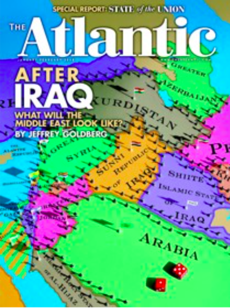
[Cover of the January/February 2008 issue of The Atlantic]
Jeffrey Goldberg, for example, made this argument in a widely quoted 2008 article in The Atlantic, titled “After Iraq.” The cover of the issue displayed the predictable ethnosectarian fantasy of a remapped Middle East (see the above image). In a follow-up piece published during the IS advance last summer, subtitled “Why should we fight the inevitable breakup of Iraq?,” Goldberg professed sympathy for the Sykes-Picot map, but asserted that its weakness had been that it was too “progressive” for the Middle East, which just “isn’t the sort of place” where “modern, multicultural, and multi-confessional states” can be established. These arguments are suggestive of how the recent proliferation of Sykes-Picot maps might bear some relation not only to the advance of IS but also to a revived sense of imperial power at this particular juncture. That is, we might read the maps less as historical explanations than as invitations, imagination-sparking supplements to the equally rapid proliferation of proposed re-mappings.
The Sykes-Picot Map
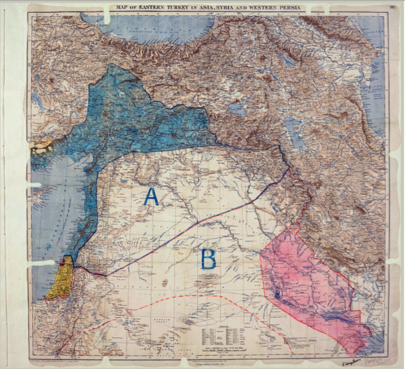
[Sykes-Picot Agreement Map signed by Mark Sykes and François Georges-Picot, 8 May 1916.
Image from UK National Archives MPK1/426,FO 371/2777 (folio 398). Image from Wikipedia.]
As historical explanation, the Sykes-Picot map does have some flaws. There are numerous versions of it, some considerably more misleading than others, especially with their creative use of colors and patterns to make the thing look as much as possible like the current map of the region. Nevertheless, the original 1916 version, signed by Mark Sykes and François Georges-Picot, is commonly used today (see the above image). The red-shaded area in the lower right of the map was to be under direct British rule. I will call this red area “Iraq,” since that is what it was called at the time, by Arabic and Turkish speakers as well as by some European officials and geographers. It included most of the Ottoman provinces of Basra and Baghdad but not the Ottoman province of Mosul or the desert region now called Anbar in western Iraq. In Sykes-Picot, it also included a significant area not in present-day Iraq, a long slice of the eastern Arabian Peninsula encompassing present-day Kuwait and the coast of present-day Saudi Arabia down to Qatar (not fully displayed on the 1916 map).
The area under direct French control in the Sykes-Picot plan, displayed in solid blue shading, consisted of a large part of southern Anatolia in present-day Turkey plus the Mediterranean coast down to Palestine. Nobody knows what to call this entity, since it is hard to match up with the map of any state today or any notion of a geographical region in 1916. The simplest solution, and the one adopted by most commentaries on Sykes-Picot, is to ignore it.
The central area of the map, the “A” and “B” territories, was to be an “independent Arab state” or “confederation of Arab states,” with the northern (“A”) region envisioned as a French “sphere of influence” and the southern (“B”) region as a British “sphere of influence.” This aspect of Sykes-Picot has been much debated, and was intended to be ambiguous at the time, or at least to be left open to future discussion. The public British stance was that the A and B territories were meant to be a single “independent” Arab state, which is how Britain claimed that Sykes-Picot did not contradict the Husayn-McMahon correspondence. But the agreement left open the possibility that they could be two independent Arab states. As for the meaning of French and British “influence,” this was also left famously vague, but it included, at least, economic concessions for each European state within its respective sphere.
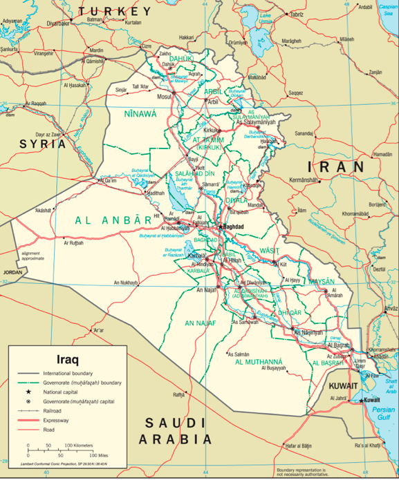
[Map of Iraq. Image from the University of Texas Libraries, The University of Texas at Austin.]
The only border of present-day Iraq (see the map above) that can possibly be called a Sykes-Picot line is the southern-most section of its border with Syria, traversing the desert region from Jordan up to the Euphrates river near al-Qa`im—though, as we have seen, this was not the border of Iraq in Sykes-Picot but the boundary between the A and B regions of the “independent Arab state.” Moreover, as I will explain in Part 2 of this article, this border was not actually established by the Sykes-Picot Agreement, in spite of the correspondence; in fact, the actions of local nationalists had a lot to do with it. The remaining, longer, section of the Iraq-Syria border, from al-Qa`im to Turkey, does not exist in any form in Sykes-Picot.
In important ways, then, the area currently under IS control looks more like the Sykes-Picot vision than does the map of Iraq and Syria. The most important, of course, is the IS conquest of the city of Mosul and the surrounding region, the most densely populated area under the group’s control. This is true regardless of how one understands the A and B territories of Sykes-Picot, since the agreement did not place Mosul within either Iraq or the “B” zone of British influence. It unambiguously placed it inside the French-influenced “A” territory, joining it with present-day northern Syria, much as IS claims it has done. At the time the group released its “End of Sykes-Picot” video last summer, it had also asserted control over a swath of present-day Iraq that was to be included in the “B” territory of the Arab state, much of it desert, though only a tiny part of Sykes-Picot Iraq, as can be seen in both the more and less expansive versions of the IS map.
Over the years, scholars have been less likely than journalists and political commentators to make patently false Sykes-Picot assertions. Some say that Iraq’s borders were created not by the Sykes-Picot Agreement of 1916 but at the Paris Peace Conference of 1919. Or maybe it was the San Remo Agreement of 1920. Or it could have been the Cairo Conference of 1921. Or there is always that London civil servant in 1922. But most of these accounts end up in the same place, i.e., that Iraq’s borders were “drawn” by Europeans sometime in the years around World War I. Reeva Simon writes:
An obvious example of an artificially created state, Iraq came into existence at the end of World War I at the behest of the British . . . They drew the new lines at the conference in Cairo in 1921 that created the country of Iraq out of the former Ottoman provinces of Baghdad, Basra, and Mosul.[3]
It is of course true that, as the years go by, the lines being drawn by Europeans—and by everyone else—do tend to get closer to the borders of present-day Iraq. But there is no originary moment in which Iraq’s borders were “drawn”; if there had been, we probably would not need all these competing narratives in the first place. As it is, we can always imagine that there is some map, somewhere, that says what we are all saying it says.
A likely reason the Sykes-Picot narrative continues to be more popular than these others, despite its obvious visual drawbacks, is that it assigns the most agency to Europeans in the process of Iraqi nation-formation. The San Remo and Cairo conferences were both, in critical ways, responses of the colonial powers to changes on the ground, and in particular to demands for Syrian and Iraqi independence, expressed in popular uprisings and armed insurgencies across wide swaths of both territories in 1919 and 1920. In fact, one very interesting way the Sykes-Picot narrative has worked, and which helps to erase the local interventions that shaped the later maps, is that all of these later maps are sometimes called “amendments” to Sykes-Picot,[4] as if one can just keep amending a secret agreement that was never legally binding in the first place, even in Europe, let alone in the Middle East. So by this rather circular logic, every new map of Iraq is said to be an amendment of Sykes-Picot, and then we can keep saying that Sykes-Picot established Iraq’s map.
A Possible Objection
To anticipate a possible objection: many proponents of the artificial state narrative might readily concede that there was no originary moment, and that Sykes-Picot, in particular, looks very little like the current map of Iraq. But they might respond that this is missing the point. The point, they might argue, is that Europeans drew the borders, and they drew them arbitrarily—that is to say, on an “empty map”—without consulting the local population and without regard for any other existing reality in the region.[5] If the map was empty, and the borders arbitrary, then who cares where they ended up?
I have two responses. First, the actual location of Iraq’s current borders sometimes matters quite a bit to the perpetuation of the artificial state narrative, and the narrative can’t have it both ways. For example, “Iraq” is very often defined by its current borders precisely in order to erase Iraq of any earlier history, thus resetting the clock to begin with the arrival of European empire. Here is an example of this familiar argument, from a widely used textbook on the history of the modern Middle East by Malcolm Yapp:
It is even more anachronistic to write of the history of Iraq in the nineteenth century than to write of that of Syria. Although the term “Iraq” was an old one, it did not correspond to the area of the modern state and was not used to designate any of the Ottoman administrative districts of the area.[6]
So now we know two things the term “Iraq” did not mean before World War I, but we still know nothing about what it did mean, let alone about the ways in which it may or may not have shaped the later history of Iraq. How was the term “Iraq” understood, we might wonder, and how did this understanding change, territorially or otherwise, from the Ottoman period to the era in which Iraq became a modern state? Why would it be anachronistic to speak of something in the nineteenth century that, as Yapp himself tells us, was spoken of in the nineteenth century? And what does it mean to say that that thing, whatever it was, did not correspond to the area of the modern state? After all, what historians are usually interested in is how things change from time A to time B. Usually, we do not simply dismiss historical change as some kind of normative failure of something to stay the same.
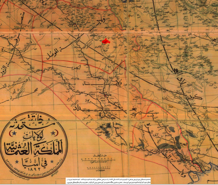
[1893 map of Ottoman Iraq. Image via Wikipedia Commons.]
The above image, an Ottoman map from 1893, shows the three administrative provinces of Basra, Baghdad, and Mosul. Stretching across the first two of these is the label al-`Iraq al-`Arabi (Arab Iraq). So Yapp is correct that nineteenth-century Ottomans did not use the term “Iraq” to designate any one of their administrative districts; rather, they used it to designate a geographical region extending at least roughly across two of those districts. This is the same region, we might recall, that we identified as Iraq on the Sykes-Picot map. Indeed, the earliest Sykes-Picot boundaries were drawn on English versions of the Ottoman map, displaying many of the geographical labels not even as English translations but rather as direct transliterations of the Ottoman terms. The image below, for example, shows a detail of the original 1916 Sykes-Picot map (the full version of which is displayed earlier in this article), with the transliterated label “Irak Arabi.” There was a good reason for this, namely that at the time of the Sykes-Picot correspondence in 1916, British troops had already occupied Basra and were battling the Ottoman army for control of Baghdad. As they conquered each region, the occupation forces retained much of the Ottoman bureaucratic structure—including many of its administrative borders and geographical nomenclature—for the purpose of governing and taxing the people of the occupied territories.
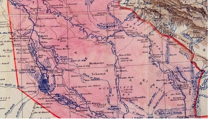
[Detail from Sykes-Picot Agreement Map shown above.]
As far as Iraq is concerned, then, the Sykes-Picot map was derived directly from the Ottoman map, even though the Iraq on neither of those maps corresponds to various Iraqs on later maps, nor is the Iraq on either map designated as an independent state. So why is it, it seems fair to ask, that a non-correspondence of borders from one time period to the next is sufficient reason for cutting off Ottoman Iraq from the later history of Iraq, while the very same non-correspondence is not a sufficient reason to cut off Sykes-Picot from that history?[7]
My second response to the imagined objection—that if Europeans drew arbitrary borders on an empty map, then it does not really matter where those borders ended up on the ground, so that Sykes-Picot works, as well as San Remo, works as well as the Cairo Conference to make the point—is that we need to look more carefully at this whole concept of an “empty map.” Timothy Mitchell has argued that a central logic of Western modernity is the production of an absolute distinction between reality and representation, “the thing and its philosophy,” the place and its map. The plan, the design, the map all seek to “make everything into a mere representation of something more real beyond itself, something original outside...The real outside was never quite reached. It was only ever represented.” The distinction between representation and reality is thus “the method by which our effect of an original ‘reality’ is achieved.”[8]
The logic of the artificial state narrative depends, I think, on this radical distinction between maps and the real world. The narrative criticizes the maps, but leaves the real world out there—rather murky perhaps, but whole and unto itself, chugging along in some non-map-affected time of its own. On the one hand, the narrative does attribute real historical agency to the European act of line drawing, which, it is certainly implied, really did transform the region by “fabricating” its modern states. On the other hand, the problem with this process, the narrative also implies, was that the maps were “empty,” that is, they had no relation to the underlying reality of the region in question. This being the case, it follows that there could be better and truer lines, existing somewhere in that non-empty and cordoned-off reality, perhaps yet to be discovered but in any case somehow more real than the lines on the maps we actually have.
Ethnosectarian Visions
This belief in the unchanging existence of better and truer lines may help explain the excitement around the “discovery” in 2005 of a “long-lost” map, shown below, that was drawn by T.E. Lawrence (as in Lawrence of Arabia) in 1918. A widely quoted Lawrence biographer proclaimed that the map “could have saved the world a lot of time, trouble and treasure,” providing the region “with a far better starting point than the crude imperial carve-up” of Sykes and Picot. NPR further explained: “For historians, Lawrence`s map is an exercise in what-ifs: He included a separate state for the Kurds, similar to that demanded by Iraq`s Kurds today. Lawrence groups together the people in present-day Syria, Jordan, and parts of Saudi Arabia into another state based on tribal patterns and commercial routes.” BBC agreed that Lawrence’s map indicated “separate governments” for the “predominantly Kurdish and Arab areas in what is now Iraq . . . But Lawrence`s suggestions came across opposition by the British administration in Mesopotamia.”
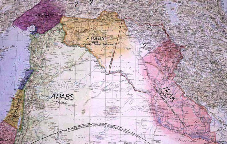
[Lawrence Map, 1918. Image from “Lawrence of Arabia, The Life, The Legend,”
Imperial War Museum, London, 2005/UK National Archives, via BBC]
The first point about these responses to Lawrence’s map is, again, the remarkable lack of correspondence between the image provided and the claims being made about it. It is not explained why we should read the two vertically aligned question marks north of Iraq as saying “a Kurdish state.” The claim is puzzling not only because Lawrence presumably knew how to spell, but also because the northern border of Iraq on his map—which is the Sykes-Picot boundary between the A and B territories—cuts right through the middle of Iraqi Kurdistan, incorporating Sulaymaniyah within the Iraqi state. The empty area with the two question marks on Lawrence’s map is not Kurdistan but the region around and including the city of Mosul.
Clearly, the reason Lawrence’s map is so popular today is that it seems to at least gesture at an effort to align state boundaries with ethnic ones, through the two states, if that is what they are, that he labels “ARABS.” And if that was the logic, then what indeed could Lawrence have used to label Mosul besides a question mark? Lawrence would have known very well that this part of Mosul was not a homogeneous or even a majority Kurdish region but an extraordinarily diverse one, home to significant numbers of Arabs (mostly Sunni, some Shi`i), Kurds (Sunni, Yazidi, and Shi`i), Turkmen (Sunni and Shi`i), Assyrians, Chaldeans, Armenians, and Jews, among others. Of course, anybody even vaguely paying attention to recent events should have some sense of this by now, too.
What these recent events should be teaching us is that following the artificial state narrative to its logical conclusion leads to one place, and that place is not peace in the Middle East but rather the violence of ethnosectarian cleansing. This is part of what IS is doing, in its effort to dismantle the “artificial” borders. Yet rather than compelling the rest of the world to rethink the logic of the artificial state narrative—which is, I repeat, the logic of ethnosectarian cleansing—the violence of IS is being marshaled as yet more evidence of that narrative’s purported truth.
When Iraq was created after World War I, the notion that states should strive for ethnic homogeneity was a new one and far from universally accepted.[9] Some nation-states were indeed formed on variations of this principle during the twentieth century, often through massive forced population transfers and sometimes through more lethal methods. The results were not homogeneous states (that seems to have been impossible everywhere) but rather states with clearly dominant ethnosectarian majorities. It hardly needs stating that, whatever else might be said of this outcome, it did not tend to improve the position of the remaining minorities. In any case, these kinds of projects have fallen out of fashion, at least in international human rights discourse and law; the official UN term for the mild versions (including population transfer) is “ethnic cleansing” and for the more extreme ones “genocide.” The narrative of Iraq as an artificial state, in its dominant manifestation today, draws on the fantasy of ethnosectarian homogeneity as the foundation of stable statehood while refusing to acknowledge the inevitable implications of that fantasy, especially in a region as heterogeneous as Iraq.
Iraqi Border Formation
As for Lawrence’s map, one thing it does tell us is that the British were perfectly aware in 1918—two years after Sykes-Picot—that no new borders had been established in this region, even though by then many lines had been drawn on many maps. British political actors involved in Middle East questions indeed loved drawing lines on maps; for some, such line drawing was a veritable pastime, if not obsession. But the maps they used were never empty, which after all would have made it a rather boring exercise. They took many things into account: mountains, deserts, rivers, and ports; known and suspected oil deposits; population densities; existing Ottoman borders, both international and provincial; previous treaty agreements and current diplomatic relations and balances of power; military strategies, gains, and losses, especially given the active wars over several of the borders through the late 1920s; and perceived local desires, demands, and conflicts as well as perceived ethnicities, languages, and religious sects.
Thus, from 1914 to 1932 there were many different and competing maps of Iraq drawn in Europe—to say nothing of those drawn in Iraq, Turkey, Syria, Jordan, Hijaz, Najd, Kuwait, and Iran. At the time, it was understood by all concerned that these maps were simply proposals and counter-proposals. Only in December 1922, after the latest border treaty between Iraq and Najd had been signed, did the lines being drawn in most of those places (with the significant exception of Turkey) start to look something like the outline of present-day Iraq. This was the result not of the whims of a civil servant in London but rather of the slow and arduous process of resolving competing claims to territory, often through war and always through the use of power. The inclusion of the Ottoman province of Mosul within Iraq, and thus the fixing of the Iraq-Turkey border, was not determined until 1926. It took another six years for Iraq and Syria to agree on their northern border. Border conflicts plagued Iraq’s relations with Iran through the 1930s and beyond. No Iraqi government recognized any border with Kuwait until 1991, when it was forced to do so after the US bombing. In short, Iraq’s borders were formed in much the same way that nation-state borders everywhere have been formed. A lot of work and a lot of violence went into their construction, and a lot of work and a lot of violence would go into their re-construction.
[This article is the first in a two-part series. Click here to read Part 2.]
[For extremely helpful comments on earlier versions of this article, I thank Beth Baron, Samira Haj, Dina Rizk Khoury, and Omnia El Shakry.]
-----------------------------------------
[1] David Fromkin, A Peace to End All Peace: The Fall of the Ottoman Empire and the Creation of the Modern Middle East, rev. ed. (New York: Henry Holt and Company, 2009), 9.
[2] See also James Gelvin, “Don’t Blame Sykes-Picot,” OUPBlog, February 7, 2015, http://blog.oup.com/2015/02/dont-blame-sykes-picot/.
[3] Reeva S. Simon, “The Imposition of Nationalism on a Non-Nation State: The Case of Iraq During the Interwar Period, 1921-1941,” in Rethinking Nationalism in the Arab Middle East, ed. James Jankowski and Israel Gershoni (New York: Columbia University Press, 1997), 87.
[4] For example, see Michael Williams, “Sykes-Picot Drew Lines in the Middle East’s Sand that Blood is Washing Away,” Reuters, October 24, 2014, http://blogs.reuters.com/great-debate/2014/10/24/sykes-picot-drew-lines-in-the-middle-easts-sand-that-blood-is-washing-away/.
[5] Indeed, the artificial state narrative does not necessarily rely on an originary moment; for a recent example, see Guiditta Fontana, “Ethno-Religious Heterogeneity and the British Creation of Iraq in 1919-23,” Middle Eastern Studies 46, no. 1 (2010), http://www.tandfonline.com/doi/abs/10.1080/00263200902760535.
[6] M.E. Yapp, The Making of the Modern Middle East 1792-1923 (New York: Longmann Group, 1987), 137-38.
[7] I am actually being generous here. In fact, Ottoman (“Arab”) Iraq looks more like modern Iraq than does Sykes-Picot Iraq, due especially to the long stretch of the Arabian coast included in the latter, which is not fully displayed on the 1916 map. (There is another Iraq on many nineteenth-century Ottoman maps, al-`Iraq al-`Ajami, or Persian Iraq; this Iraq likewise appears on some early Sykes-Picot maps, as “Irak Ajemi.”)
[8] Timothy Mitchell, Colonising Egypt (Berkeley: University of California Press, 1991), 172-73.
[9] For two somewhat different accounts of the history of this concept, see Mark Mazower, No Enchanted Palace: The End of Empire and the Ideological Origins of the United Nations (Princeton: Princeton University Press, 2009); Sarah Shields, Fezzes in the River: Identity Politics and European Diplomacy in the Middle East on the Eve of World War II (Oxford: Oxford University Press, 2011).