This map (Fig.1) shows a section of modern Cairo in 1946, developed from the 1860s onwards to the west of the historic city (founded 969 C.E.). The map focuses on the downtown area or roughly what came to be called Wist al-Balad—the middle-of-the-city (country?)—curiously bounded in pink on three sides. Intense curiosity about the boundary prompted this article: What did the boundary delimit and protect? What does it disclose about Cairo’s history? And what does it reveal about Cairo’s presumed continuous fabric?
Despite its innocuous look, this Bounds Map is a veritable palimpsest. To begin with, the 1946 map is literally an overlay drafted for the British Ministry of Defence over a 1943 base-map by the Survey of Egypt. Overlaid in pink hue, the classified map depicts areas considered “Out of Bounds” for British occupation troops and personnel, and for remnants of WWII allied troops under Great Britain’s unified command for the Middle East headquartered in Egypt. The boundary frames an area of safe movement within modern Cairo for those two armies, some 140,000 strong throughout Egypt during the war. Roads to be taken only “in conveyances” cut through the colored fabric, leading to other British barracks and training camps around the city and across the Egyptian landscape.
The pink overlay simultaneously suppresses and reveals more layers of reading. Because a thorough examination of such layers warrants a longer article (in process), this article attempts only a pointed exposé. With the aid of other historical maps besides socio-economic studies on the periods from the late-nineteenth century through post-WWII, the article pares three primary layers of this palimpsest. This archaeology of maps defamiliarizes a city romanticized in Egyptian and Arab memory through interwar black and white film. The article reveals peculiar urban formations nestled in Cairo’s fabric, evolving over time but consolidating particularly after WWI. Such formations allowed downtown Cairo to play crucial socio-economic and military roles during that period, and whose impacts on the fabric pronounce significant discontinuities from surrounding areas. Exposing the map’s implicit layers and buried traces, the article sheds new light on Cairo’s socio-spatial history, and establishes grounds for future research on their deeper causes.
Layer One: An Implied Enclosure
Produced in April 1946, two months after the violent anti-occupation protests in Ismailia (now Tahrir) Square and elsewhere, this version of the Bounds Map was used by the British military to navigate movement until they evacuated Cairo in March 1947. Earlier versions of the map were drawn during (and probably before) World War II to delineate how the bounds shifted in response to events in the increasingly-hostile city (Sansom, 1965). For instance, brothels along Clot Bey Street (north of al-Azbekiyya Park) were occasionally rendered out-of-bounds during the war, since they could not be inspected by medics for venereal diseases; moreover, allied soldiers were repeatedly assaulted by “terrorists” in the area’s dark twisted alleys.
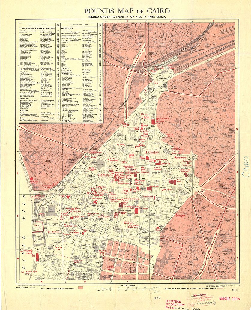
[Fig.1: The Bounds Map, Cairo (partial) 1946, scale 1:5000.
For a higher resolution, see interactive view, © The British Library Board]
But while the outer bounds fluctuated, the core area (encompassing al-Ma’adi neighborhood off-map south, and al-Zamalek island off-map west, where high-ranking British military officers, prominent civilian expatriates and elite Egyptians resided) remained largely unchanged. Within its bounds (see zoomable map), the mapmaker highlighted key buildings including military, religious and entertainment facilities as well as financial establishments. Figure 2 shows the British military facilities and Egyptian police stations (overseen by colonial authorities) dotting the bounded zone and ringing its perimeter. Politically-sensitive urban locations were within a short rolling distance for armored vehicles and troops from the distributed barracks and/or camp-grounds. Thus, on 4 February 1942, the British deployed tanks from Qasr al-Nil barracks to swiftly seize control of ‘Abdin Palace, in order to coerce Egyptian King Faruq into appointing a more pro-British government. Similarly, al-Azbekiyya grounds were repeatedly used for assembling troops to quell unrest particularly from al-Azhar’s direction.
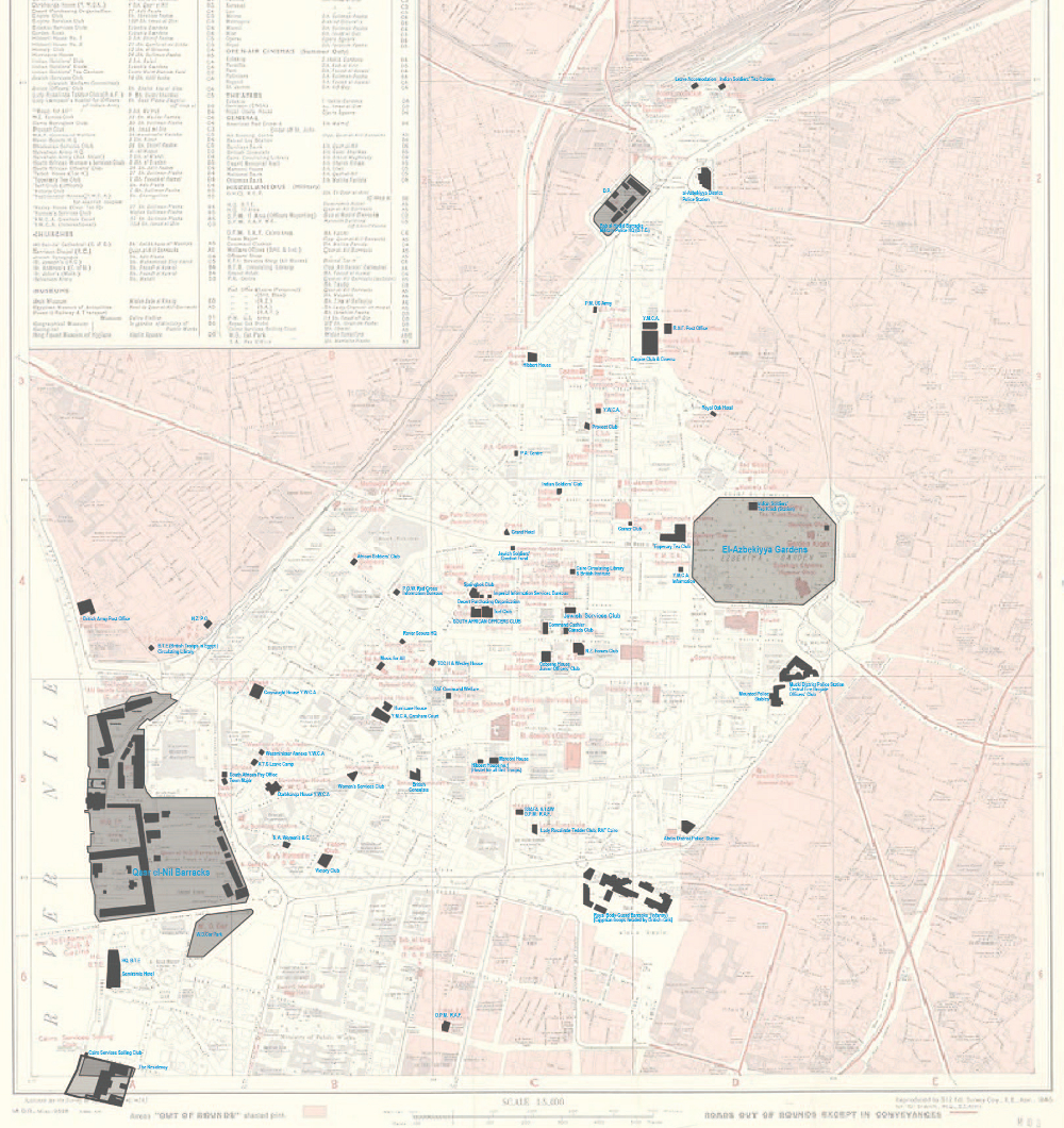
[Fig.2: British Military installations and related facilities, including: Headquarters for the two armies under British command in Garden City neighborhood; the main British barracks overlooking Ismailia Square; parking for military vehicles occupied the site where Mogamma’ al-Tahrir sits today; another barracks with an internment center close to Cairo’s Maydan Bab al-Hadid across from an Egyptian police station; a British officer headed the Egyptian infantry division of the royal guards outside ‘Abdin Palace; British troops used al-Azbekiyya Park grounds as an assembly area and dissemination point; al-Gezira club grounds in Zamalek also served to billet off-duty troops. Besides military installations, the area comprised a considerable number of clubs and entertainment facilities for troops of different dominions, ranks and genders, including: cinemas, music halls, YMCAs and YWCAs, officers’ clubs and tea rooms.
Credit: author, base map ©The British Library Board].
Given such military facilities in and around, one is forgiven to perceive the bounded area as a military stronghold if without physical walls. The impression is confirmed by the British Army’s 1942 Civil Security Scheme [Fig.3] and concurrent reports by British military intelligence which identify “potential centers of disturbances” encircling the area (Sansom,1965). Yet, there are persuasive reasons to suggest that the bounded zone represented more than the temporary wartime exigencies of an occupying power imposed onto a restless city. First, primary military facilities occupied their urban positions since at least 1898, including Qasr al-Nil barracks, the British Residency, Qasr ‘Abdin’s barracks and military-administration facilities. By 1920, all military and police facilities along the zone’s perimeter were in place, some of which were added only after 1914, including the barracks and police station overlooking Maydan al-Mahatta, the soldiers’ stations inside al-Azbekiyyeh Park and the ‘Abdin police station. After WWI, the iconic Wist al-Balad doubled as a quasi-Green Zone.
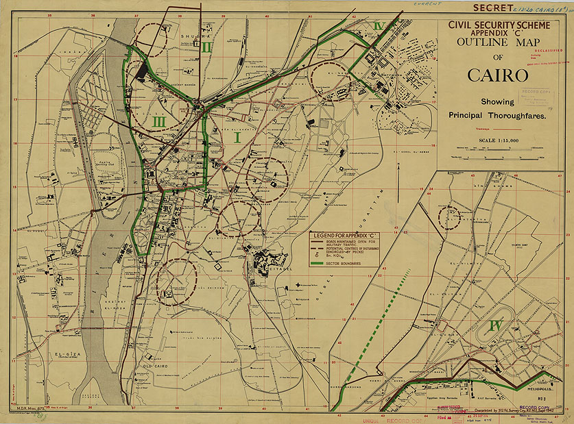
[Fig.3: Civil Security Scheme 1942, prepared for the General Headquarters Middle East Forces, the British central command for WWII allies. The map outlines distinct security zones in green, and demarcates sources of unrest in dashed circles (or “pecks”).
Credit:©The British Library Board. For a higher resolution, see interactive view.]
Another reason for inferring a more fundamental, enduring role for the bounded zone concerns the assemblage of financial establishments, political institutions and real-estate developments that it came to enclose by the interwar period. As the next section argues, these institutions supported a system for wealth concentration that relied on intertwined relationships among the British occupiers, European financiers, and local elites. The zone’s boundary and its component institutions were mutually-constitutive.
Layer Two: Wealth Concentration
Besides housing various facilities for military and security forces, modern Cairo enclosed an intense concentration of the nation’s wealth. Tony Cliff argued that, in 1942, six banks directly controlled about ninety-four percent of the country’s financial assets (£E162.2 million): “The National Bank of Egypt, Crédit Foncier Egyptien, Banque Misr, Crédit Agricole d’Egypte, Land Bank of Egypt and Banque Belge et Internationale en Egypte”. Other banks were mere subsidiaries of the big-six, with total assets around £E10 million. Five of the big-six banks, holding £E156.5 (ninety-one percent) of total assets, had their headquarters within modern Cairo’s bounded zone. Robert Tignor’s (1984) more cautious estimates paint a similar picture of the country’s wealth concentration in the 1930s-40s; while more than Cliff’s big-six, the primary financial establishments Tignor foregrounds were headquartered within downtown Cairo [Fig.4]. Significantly, an antecedent cartel of financial establishments clustered from the mid-1880s till post-WWI in al-Azbekiyyah district, Khedival Cairo’s original business-cum-entertainment center. There, while still largely within bounds, they were closer to business from Cairo’s historic city. In the mid-1880s, Banque d’Egypte even resided on al-Mosky Street, one of the eastern city’s most popular thoroughfares. By the mid-1920s, the financial center of gravity shifted southwestwards away from the primary gateways into the historic city, to Wist al-Balad closer to the main cluster of military facilities and governmental institutions.
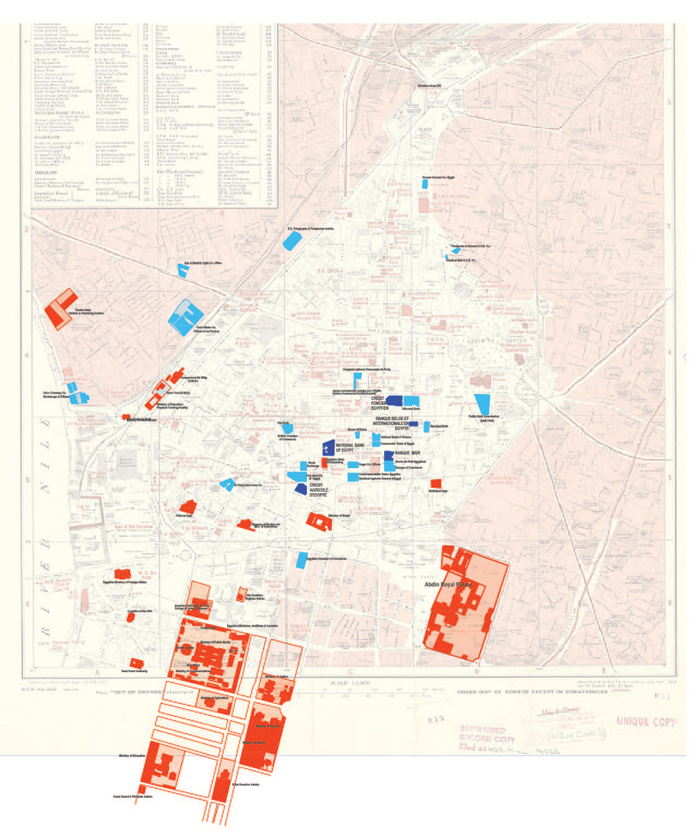
[Fig.4: Cliff’s Big Banks, dark blue; other banks, financial Institutions and shareholder companies, light blue;
Egyptian ministries, departments and royal palace, red. Credit: author; base map ©The British Library Board].
Egypt’s wealth was primarily held in Europe (including Britain) since the 1870s. In 1914, besides an immense public debt of £E85,680,000, overseas shares in Egyptian-based companies exceeded seventy-one percent (£E71,250,000; Tignor, 1984). In 1937, foreigners owned 45-50 percent of the country’s entire wealth, including land value. Gradually, Egyptian financial institutions came to hold more capital, if still owned and/or controlled by European interests; still, throughout the 1920s-30s, they were directed by European-based committees more than their directorship boards in Cairo (Tignor, 1984). By 1942, while Banque Misr, the only predominantly-Egyptian bank among Cliff’s big-six banks, held only 12.9 percent of Egypt’s financial (£E20.9 million), European interests controlled four of the big-six, or 78.7 percent of total assets. In effect, colonial powers used in-zone banks to concentrate local wealth and funnel its dividends to an emerging world market, the offspring of colonialism, which they exploited together despite their rivalry.
British interests—the financial arm of the British occupation—commanded extensive stakes in this financial wealth and attendant political clout. While the British government held fourty-four percent of shares in the strategic Suez Canal, British financiers controlled some sixty percent of Egypt’s financial assets in 1942. Alongside numerous investments in infrastructure, joint-stock companies and other banks, British financiers maintained majority shares in the privately-owned National Bank of Egypt, by far the wealthiest among the big-six with assets around £E91.4 million, subsidiaries notwithstanding. Moreover, as the sole currency issuer and primary lender for the Egyptian government, this bank exercised substantive influence on Egyptian affairs (Tignor, 1984).
A closer look at this wealth concentration process exposes entangled economic and political networks within the bounded zone and identifies the elite classes’ growing role in them. Besides an extensive exchange of capital, shares and credit among financial institutions, the directorships of banks and companies also shared board-members. In 1943, over one-third of the directorships of the 441 registered companies (from transport, industry, energy, banking, insurance, finance, hospitality and entertainment) were dominated by only sixty-six men: a mix of Egyptians, Europeans (British, French, Belgian and Italian), foreigners (Syrians, Greeks, Jews and Armenians), and residing expatriates from all backgrounds. Some Egyptian and naturalized board-members’ careers also traversed the halls of government where they served as high state functionaries at some point, including three prime ministers, twenty-five ministers, and about thirty parliament representatives. In turn, Egyptian government institutions, located primarily in-zone along Qasr al-‘Ayni Street (Fig.4) and dominated by large landowner families, were surreptitiously managed by British and French bureaucrats (Rodenbeck, 1999).
By 1946, company-boards with such mixed ethno-cum-political affiliations increased to forty-eight percent of total Egyptian companies, and more such companies were directed from downtown Cairo, not European cities. Thus, the elite pool had thoroughly intermixed and consolidated its influence, suggesting an emerging haute bourgeoisie sharing economic interests and Europeanized cultural traits (Tignor, 1984). Among them, foreign nationals (including Egyptians with dual-citizenships) also enjoyed legal privileges guaranteed by Consular Courts until 1937, then the Mixed Tribunals until 1949, and whose different buildings resided in-zone since the nineteenth century. In effect, an elite social stratum had developed into a semi-independent operative concentrating capital for its own welfare alongside colonial accumulation. Such elites also exercised political authority under colonial aegis, particularly through parliament. To manage business, coordinate interests and thereby funnel wealth into the colonial market, financiers-cum-businessmen-cum-politicians shuttled within overlapping networks of banks, companies, courts, governmental institutions and halls of political authority, set within downtown Cairo’s urban fabric, surrounded by the British military and the British-influenced Egyptian police.
Another form of wealth concentration developed alongside this financial culture of collaboration. It consisted of increased investment in modern Cairo’s real estate during the inter-war period. A brief historical detour helps clarify this trajectory. Starting in the1860s, the initial khedivial city of Cairo developed as a low-density expansion west of the historic city [see Cairo 1874 map]. Besides governmental ministries occupying large urban blocks in al-Qasr al-‘Ayni area and the theatre district around al-Azbekiyya Park, the new city contained primarily single-family villas and palaces amid gardens on sizeable plots doled at cheap prices (or cost-free) by the Khedives to family members, to al-‘a’yan (the landowning class) and to foreign entrepreneurs. Besides cheap land, initial investment in the khedival city’s public works was not intensive (Hershlag, 1980). Between the 1890s-1907, increased investments added public buildings, schools and infrastructure (including roads, canal-land reclamation and light-rail lines) to modern Cairo. Land values soared with this boom, although urban densities remained low. Post-WWI, downtown land prices further increased (although devalued during the 1930s Depression), while building heights and gross floor-areas multiplied manifold; wealth accumulation through real estate accelerated. Thus, taking al-Immobilia site (overlooking Qasr al-Nil and al-Madabegh, later Sherif, streets) as indicator, one finds that its land value increased over tenfold between 1882 (£E1.79 per square-meter) and 1908 (£E21.18 /sqm), but then decreased to £E16.53 /sqm by 1937 (Volait, 2012). Meanwhile, interwar and post-WWII urban developments were high-density and capital-intensive: palace owners, such as the financiers al-Qattawi family of Soliman Pasha Square, moved to outlying suburbs (Ma’adi, Heliopolis, …etc.) selling their increasingly coveted land to make way for denser mixed-use developments. Buildings erected in the 1920s-40s, like al-Immobilia (1937-41) tended to occupy their whole plot, and to approach eighteen floors in height; Fig.5 demonstrates the increased in-zone urban densities. New developments also catered primarily to the elite clientele of local and foreign businessmen discussed above, and their circles of artists and auteurs.
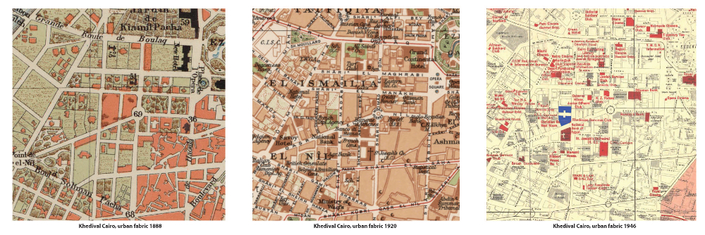
[Fig.5: A comparison of the densities of Khedival Cairo’s urban fabrics in1888, 1920 and 1946. The fabric sample is centered
on the site of the Immobilia Building (blue, right). Cairo 1888: public domain; Cairo 1920: Courtesy of the Library of Congress,
USA & Maslahat al-Misaha, Egypt; Cairo 1946: ©The British Library Board]
Layer Three: Urban Discontinuities
This progressive concentration of wealth in the business institutions and real estate of Cairo’s downtown set it sharply apart from surrounding urban fabrics. No major financial institutions located their headquarters outside the zone’s boundaries after the 1890s (although several infrastructural and industrial companies did). Some plots in the Garden City neighborhood reached about ten times land prices in the eastern city by the early 1950s; downtown plots possibly exceeded this ratio in the 1930s. Concomitantly, the zone developed distinct urban features in its building densities, vertically-layered spaces and peculiar sense of scale contrasting tall buildings against broad avenues. Furthermore, scrutiny of Cairo’s 1920 map (figure-6a) reveals the scarcity of mosques within the bounded zone compared to the historic city; in 1946, the in-zone mosque shortage persists (Fig.6b). Arguably, Egyptian churches suffered similar shortages in-zone. Close inspection of the maps also show the in-zone mosques’ transformed morphological relationships. Rather than being formative of spatial networks of landmarks, public-space enclaves and street itineraries as in the historic city, downtown mosques, where they occurred, fit as any other structure within a pre-configured framework. Generally, collective memory in the modern city follows an altogether different morphology. It forgoes the historic city’s milieu of diffuse mnemonic registers (including mosques, shrines and dedicated sabils) closely interwoven with everyday-life rituals and recollections of historic events. Instead, in a Haussmannesque turn, the modern city foregrounded isolated, self-referential objects with prescribed historical narratives and only weak involvement in urban rituals. Hence memorial statues like Mostafa Kamil’s in his namesake traffic circle (1940) and the grandiose Mixed Tribunals Building (High Court of Justice; late-1920s) on Fouad I Street.
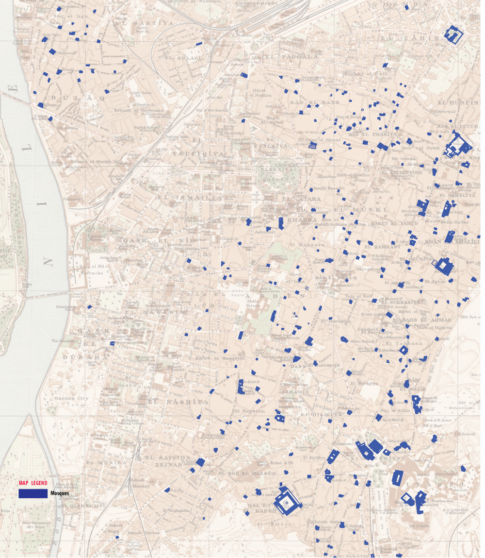
[Fig.6a: The distribution of mosques (blue polygons) throughout the main neighborhoods of Cairo (excluding northern and southern suburbs) in 1920. The graphic shows the shortage of designated mosques in downtown Cairo. [By author; base map Cairo 1920: Courtesy of Maslahat al-Misaha Egypt and the Library of Congress, Geography and Map Division].]
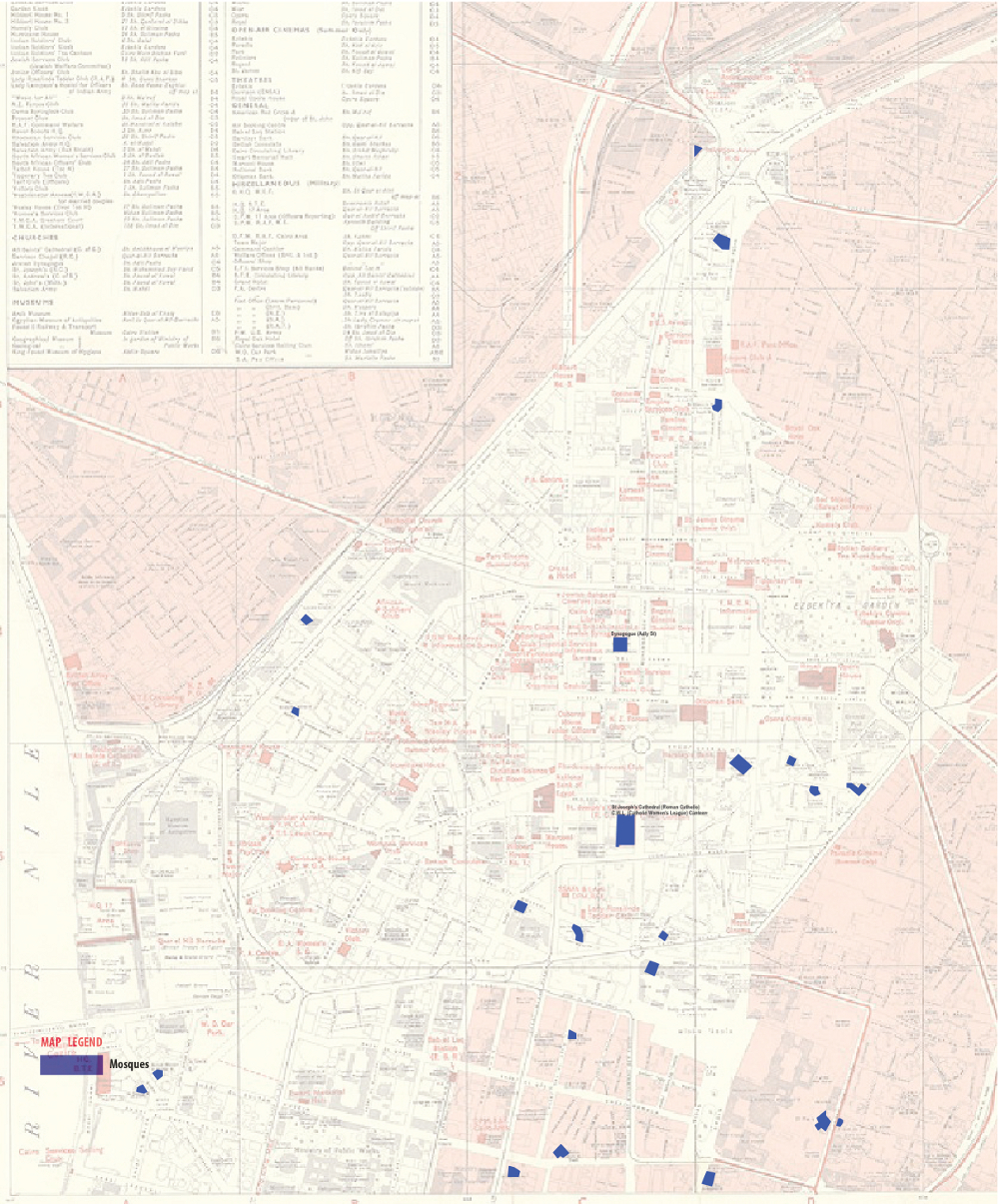
[Figure-6b: The distribution of mosques (blue polygons) in downtown Cairo in 1946 remains scarce.
Credit: author; base map ©The British Library Board].
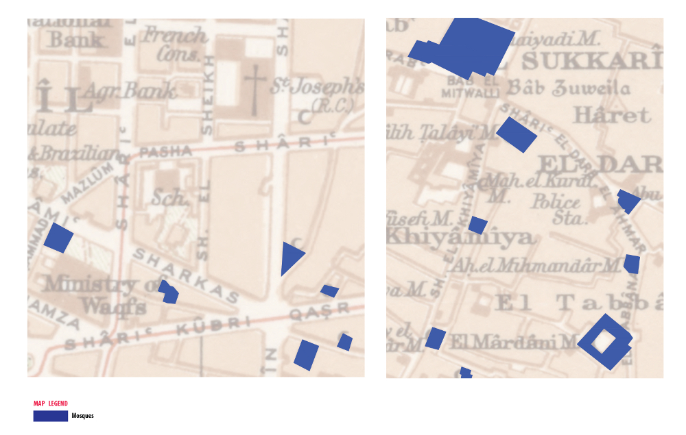
[Fig.6c]
The material and cultural qualities of the bounded zone were geared predominantly towards the emergent, ethnically-mixed haute bourgeoisie with European cultural leanings and their foreign collaborators. Within downtown Cairo of 1910, foreigners outnumbered Egyptians threefold (Rodenbeck, 1999); although more Egyptian elites moved in during the 1920s-40s, they adopted similar cultural biases. Conventional Egyptians could dwell in the modern city only with transformed cultural orientations. Otherwise conflict and/or tragedy ensue, as key works of period literature demonstrate: In Naguib Mahfuz’ Cairo Modern (1945), Midaq Alley (1947), The Beginning and the End (1950) and even Palace Walk (1956), characters from surrounding neighborhoods suffer death, humiliation or moral disgrace when they traverse the bounds.
Thus, besides a boundary implied by military installations, significant discontinuities abounded in land uses and values, building heights and densities, development opportunities and social stratum, as well as modes of collective memory. Unlike the sharp demarcation of the occidental town from the oriental city in French colonial urbanism Cairo’s bounded zone represented an economic-cum-colonial rift more than a historical divide. It exhibited subtler discontinuities from all surrounding areas: Cairo’s modern northern neighborhoods (e.g. Shobra) besides its historic city. Significantly, the bounded zone developed despite crucial morphological transformations since the late nineteenth century: When al-Khalig al-Masry canal (east, now Port Said Street) was filled-in by 1900, and al-Isma’ilia canal (west, now al-Galaa’ Street) was reclaimed by 1914, they created the potential for increased east-west connectivity among the city’s different neighborhoods. In effect, the conjoined military-political-financial alliance of Cairo’s bounded zone contradicted the khedival city’s original continuous configuration, and counteracted the morphological predisposition of the growing capital towards more connectivity.
Such fundamental transformation only results from systemic policies. Indeed, with its wealth concentration in institutions and real estate, its political culture closely entangled with colonial authorities and surrounded by colonial-controlled security forces, Cairo’s bounded zone bore uncanny resemblance to the socio-economic dynamics and urban features of colonial civil stations. Civil stations were newly-built self-contained settlements that British authorities built as professional, financial and cultural centers for their civilian administrations in most of their colonies in the nineteenth century. While not restricted to colonized populations, their detachment from existing indigenous towns allowed British authorities to control the locals’ accessibility while exploiting their labor. By the late nineteenth century, civil stations gradually developed economic and educational institutions to entice the local elites. As William Glover demonstrated for Lahore’s (2007), civil stations evolved to fulfill the crucial role of assimilating and co-opting elites into co-exercising colonial authority over the poor majorities.
Colonial civil stations were widespread in Britain’s Indian and African colonies (FO and WO archives), but also in Mandate Iraq, which shared many of Egypt’s cultural and urban conditions. Although nowhere in such archives was Cairo designated as a civil station, British authorities likely employed a similar administrative model in Egypt. But since downtown Cairo predated Britain’s 1882 takeover, I posit that British authorities transformed its pre-existing physical fabric to match their colonial administrative model: to concentrate wealth and political authority within it; to nurture an elite local class for collaboration on such goals; and to make its different areas swiftly accessible to intervention by security forces when needed.
Conclusion
In the palimpsest of the 1946 Bounds Map lie traces of Wist al-Balad’s different roles in maintaining colonial authority. Just like it was a quasi-Green Zone, Cairo’s bounded zone was also a pseudo-Civil Station. Elaborating this hypothesis requires a longer argument which simultaneously accounts for the source(s) of wealth concentrated within bounds. In a future essay, I explore how this bounded zone usurped the wealth generated by agriculture, Egypt’s predominant sector of economic production from the nineteenth century well into the 1960s. Indeed, there is yet another historical layer to unfold from the Bounds Map, a longer-dureé story of “metabolic rift,” or the transfer of wealth and value from the countryside to the city—a rift whose attendant urban practices have recurred in varying guises, and whose entrenched alienations still persist.
References
Documentation relating to Egypt/Sudan 1839-1958 (Foreign and War Office Collections). Confidential Print: Middle East, 1839-1969. The National Archives, UK.
William J. Glover, Making Lahore Modern Constructing and Imagining a Colonial City (Minneapolis: University of Minnesota Press, 2007).
Zvi Yehuda Hershlag, Introduction to the Modern Economic History of the Middle East (Leiden: Brill, 1980).
Max Rodenbeck, Cairo: The City Victorious. 1st American ed. New York: Knopf, 1999.
A.W. Sansom, I Spied Spies (London: George G. Harrap Co. Ltd., 1965).
Robert L. Tignor, State, Private Enterprise, and Economic Change in Egypt, 1918-1952 (Princeton Studies on the Near East, Princeton University Press, 1984).